414295
- TitleOriginal Sketches, Drawings, Maps etc Collected by Admiral Isaac Smith / drawings and watercolours, mainly of Captain Cooks Second Voyage (1772-1775) by William Hodges, Henry Roberts etc
- Creator
- Call numberSAFE/PXD 11
- Level of descriptionfonds
- Date
1768 - 1775 - Type of material
- Reference code414295
- Issue CopyDigitised
- Physical Description1 album (disbound, 88 drawings, 1 engraving and cover) - album 49 x 70 cm
- Scope and ContentVOLUME 1
ia -- COOK, JAMES - A Plan of the Harbour of St Johns in Newfoundland.
ib -- COOK, JAMES - A Plan of the Harbour of Croque in Newfoundland.
ii -- COOK, JAMES - Four profiles of the coast of Terra del Fuego, a Plan of Success Bay in Strait le Maire and a Chart of the S.E. part of Terra del Fuego.
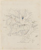
iii -- COOK, JAMES- Sketches of the islands lagoon, Thrum-Cap, Bow-Island, the Two Groups, Bird Island and Chain Island, lying in the South-Sea ... discovered in Apl 1769. / Note in ink under title 'Note. the prick'd line shews the ship track in which she Passes the Islands'.
iv -- SMITH, ISAAC - Tegadoo Bay, New Zealand. 23. Oct 1769.
v -- SMITH, ISAAC - Natural arch, 75' long, 27' broad, 45' high, Tegadoo Bay, New Zealand.
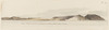
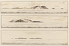
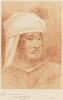
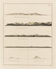
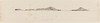
1 -- HODGES, WILLIAM (a) Profile of the coast of the Isle of Mayo, Cape Verde Islands. (b) Profile of the coast of Isle of Mayo Cape Verde Islands, looking north west.
2 -- HODGES, WILLIAM (a) Profile of the coast of the Isle of Mayo. / Similar to view at f.1 but scale is smaller and the hill marked 'B' is completed. (b) Profile of the Isle of Mayo. Similar to view at f.1 but scale is smaller.
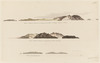
3 -- HODGES, WILLIAM - Profile of the Island of St.Jago, Cape Verde Island. Titled 'The Island of St Jago where the point D bears WSW distant 3 leagues. AA joins'.
VOLUME 2
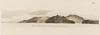
3a -- HODGES, WILLIAM - Chart of Port Praya in the Island of St Jago,Cape Verde Islands. Titled 'Port Praya in the Island St Jago one of the Cape de Verds sic A scale of 2" to 1/2 a mile'. / A View of Port Praya taken from the anchoring place.
3b -- View of unidentified island. In ink on left hand side 'N by E' and on right hand side 'E by N'. Attributed to Hodges.
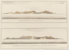
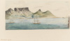
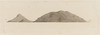
4 -- HODGES, WILLIAM - View of Porto Santo extending from NNW to WBW distant 5 miles
5 -- HODGES, WILLIAM - View of Porto Santo bearing North distant 2 Leagues.
6 -- HODGES, WILLIAM - Island of Bonavista: 2 Profiles. Titled: 'Island of Bonavista S.W. distant 5 leagues' and 'The Island of Bonavista when the hill A, off which lies a ledge of rocks bears west 2 leagues'.
7 -- HODGES, WILLIAM (a) View of Porto Santo. Titled in ink along lower edge 'View of Porto Santo extending from NNW to WBW distant 5 miles' (b) View of Porto Santo bearing north. Titled in ink lower edge 'View of Porto Santo bearing north distant 2 leagues'. (c) View of the Deserters.
8 -- HODGES, WILLIAM (a) View of Porto Santo Titled in ink below view 'View of Porto Santo extending from NNW to WBN distant 5 miles'. Title also written faintly in pencil along upper edge. Similar to view at f. 7. (b) View of Forto Santo bearing nort Titled in ink below view 'View of Porto Santo bearing north distant 2 leagues' Title also faintly in pencil along upper edge.
9 -- View of the Deserters Titled in ink lower edge and in pencil near right hand edge.
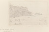
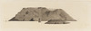
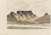
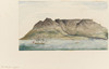
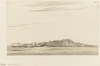
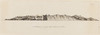
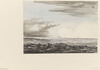
10 -- HODGES, WILLIAM - Table Mountain, Cape town.
11 -- HODGESS, WILLIAM - Table Mountain, Cape town.
12 -- HODGES, WILLIAM- Table Mountain, Capetown.
VOLUME 3
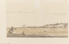
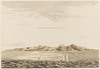
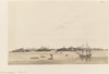
13 -- ROBERTS, HENRY - Matavia Bay, Otaheite. Unsigned. Appears to be by the same hand as f.16 which is signed.
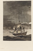
14 -- HODGES, WILLIAM- The Otaheite fleet at Appany Bay. Signed %H.-74 ' in ink lower left corner.
14b -- Diagram of a double canoe seen at Amsterdam in the South Seas, Unsigned and undated. Explanation on a separate sheet below diagram.
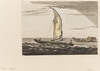
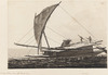
15 -- HODGES, WILLIAM - War canoe, Otaheite.
15a -- HODGES, WILLIAM - Canoes, Otaheite.
16 -- ROBERTS, HENRY - Otaheite, when Point Venus bears S.W. by W. 5 miles distant. Signed 'H. Roberts' in ink upper right corner.
17 -- HODGES, WILLIAM Potatow, the Otaheite admiral. Titled in ink on mount in Canon Bennett's hand 'Potatow "The Otaheite Admiral", The original sketch for the finished drawing. Engraved. Second Voyage. W.Hodges'.
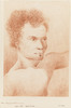
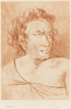
18 -- HODGES, WILLIAM - Otaheite native.
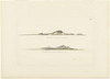
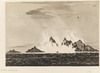
19 -- ROBERTS, HENRY (a) Profile of Middleburg Island. Signed 'Heny Roberts' in ink lower right corner. Title printed in ink below view 'Middleburg Island bearing W by S distant 3 leagues' (b) West point of Middleburg Island. Signed Heny Roberts in ink lower right corner. Title printed in ink below view Wewst point of Middleburg N by W four miles (c) ROBERTS, HENRY Middleburg Island profile. Title printed in ink beneath view Middleburg E by S distant five miles (d) Amsterdam Island profile. Signed Heny Roberts in ink lower right corner. Title printed in ink below view Amsterdam Island when the south point bears west distant four miles. (e) Plystuart Island: two profiles. Signed Heny Roberts in ink lower right corner. Titles printed below views Plystuart Island SW distant nine leagues and Plystuart NWbN distant six leagues.
19a -- HODGES, William Portrait of a native
VOLUME 4
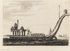
20 -- HODGES, WILLIAM A large sailing canoe of the Friendly Islands
21 -- HODGES, WILLIAM - A Fishing canoe of the Friendly Islands.
21a -- Diagram of a native canoe. Unsigned and undated.
22 -- ROBERTS, HENRY - Huaheine, one of the society Islands.
23 -- ROBERTS HENRY - Ulietea, on of the Society Islands.
24 -- ROBERTS, HENRY The Bay of Amsterdam, Friendly Islands.
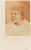
24a -- HODGES WILLIAM - Otago, chief of Amsterdam Island. Titled in ink on mount in Canon Bennett's hand ' Otago Chief of Amsterdam Island. Original sketch, Engraved. Second voyage. W. Hodges.'
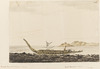
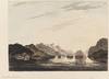
25 -- HODGES, WILLIAM Resolution Bay in the Marquessas. 1774. Unsigned, Titled and dated in ink on mount 'Resolution Bay in the Marquesas March 1774' in Canon Bennets hand.
VOLUME 5
25a/a -- ROBERTS, HENRY Eimeo as it appears from Matavai Bay; Otaheite. Signed 'H Roberts' in ink lower right corner.
25a/b -- Profile of Osnabrug Island. Titled in ink lower edge of view 'Osnabrug Island. Bearing S. by W. 5 leagues distant.'
25a/c -- Profile of Dominica Island. Titled in ink lower edge 'I Dominica bearing from N by W to ESE distant 1 1/2 mile'..
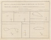
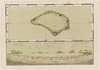
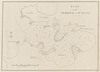
25b/a -- Map and profile of Plamerston Island. Titled in pencil upper left corner 'Palmerston Island Lat.18 S Long 13.5 W'. 'Palmerston' written faintly in pencil in middle of view.
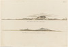
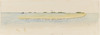
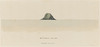
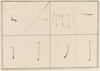
25b/b -- Profile of unidentified Pacific Island showing a lagoon. Unsigned, untitled and undated. 'North' printed in ink above horizon.
25b/c -- Profile of unidentified island. 'W' printed in ink. left hand side, 'N' on right hand side. 'A league off shore' written in pencil along lower edge
25b/d -- Profile of unidentified island. E printed in ink left hand side and SSW on right
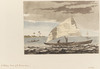
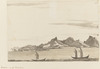
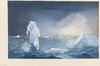
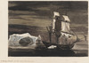
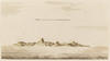
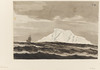
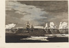
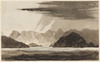
26 -- HODGES, WILLIAM - The Resolution and Adventure, 4 Jan, 1773, taking in ice for water, lat. 61.S.
27 -- HODGES, WILLIAM - Ice Islands.
27a --HODGES, WILLIAM - Ice Island.
28 -- HODGES, WILLIAM Ice islands with the Resolution and Adventure.
29 --HODGES, WILLIAM - Ice Islands.
30 -- HODGES, WILLIAM - Ice Islands. Possibly by Georg Forster
VOLUME 6
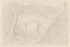
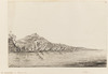
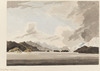
31 -- HODGES, WILLIAM - In Dusky Bay, New Zealand.
32 -- HODGES, WILLIAM - Dusky Bay, New Zealand.
32a -- HODGES, WILLIAM - View, possibly of Dusky Bay, New Zealand
32b -- HODGES, WILLIAM - Portrait of a Maori. Titled 'New Zealand' and signed 'W.Hodges' in ink on mount in Canon Bennett's hand.
33 -- HODGES, WILLIAM - The Island of South Georgia.
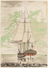
34 -- ROBERTS, HENRY - The Resolution. Signed 'H Roberts' in ink in lower right hand corner.
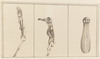
35 -- Three native idols Unsigned, untitled and undated.
36 -- Native weapons. Unsigned. untitled and undated.
37a -- Sketch of Block Island. Titled in ink upper left corner 'Sketch of Block Island. Latd of South Head 41.9H'
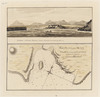
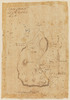
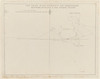
37b -- Map of Charles, Town and state of the Kings troops March 11 1780. Unsigned and undated. Titled as above in pencil along lower edge. Key in pencil lower left corner.
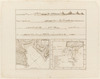
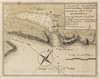
37c -- Plan of the harbour of St. Lucia. Titled in ink upper right corner with 'West Indies' written below in penci. Scale of fathoms in lower left corner.
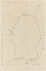
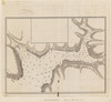
38a -- Map of S. Andheman Island. Titled S. Andeheman Island' in pencil upper left edge. Gives latitude and longitude
38b -- The Track of His Majesty's ship Perseverance between Rutland and the Cinque Islands. Unsigned and undated. Titled in ink along upper edge. Scale of 5" = 10 nautical miles. - Access Conditions
Access via appointment - Copying ConditionsOut of copyright: Artist died before 1955.
Please acknowledge:: Mitchell Library, State Library of New South Wales - General note
For detailed analysis of the contents and provenance of this album see Rudiger Joppien & Bernard Smith, The Art of Captain Cooks voyages The Voyage of the Resolution and Adventure, 1985, particularly pages 122-125.
On Exhibition: Cook 15/3/89 - 17/7/89
Digital order no:Album ID : 823696
Album disbound in 1984. Original album cover kept with drawings. - Signatures / Inscriptions
Titled in ink, by Canon Bennett, in original album 'Original Sketches, Drawings, Maps etc Collected by Admiral Isaac Smith. Who served as an Officer under Captain James Cook, the Circumnavigator in his First & Second Voyages. Ad. 1768-1775'
On front flyleaf of original album cover ""Fredk Bennett. The Vicarage. Shrewton-cum-Maddington: Wilts""
Also in original album is a two page contents list, above which is inscribed by Bennett 'Index. Mss Admiral Isaac Smith'.
On front end paper of original album covers is pasted an Australian Museum Library label, with accession no. 7440 - Creator/Author/Artist
- Name
- Subject
- Topic
- Place
- Exhibited in
Dare to know : the art and science of Pacific voyages - State Library of New South Wales (1 June - 28 November, 1998)
William Hodges - National Maritime Museum (Great Britain). Applies to: ff. 27(a) ; 31
Vaka Moana: voyages of the ancestors - Auckland Museum
Cook & Omai : the cult of the South Seas - National Library of Australia (February 2001 - June 2001). Applies to: f. 26; 28
Cook & Omai : the cult of the South Seas - National Library of Australia (February - June 2001)
ONE hundred : celebrating the Mitchell Library centenary - State Library of New South Wales (March 2010 - June 2010). Applies to: f.26
Finding Antarctica - State Library of New South Wales (November 2011 - February 2012). Applies to: PXD 11 f,30
Arctic Ambitions: Captain Cook and the Northwest Passage (Anchorage Museum Alaska) - Anchorage Museum, Alaska (March 2015 - September 2015). Applies to: Volume 5
Arctic Ambitions: Captain Cook and the Northwest Passage (Washington State Historical Society, Seattle) - Washington State Historical Society (October 2015 - January 2016)
Maps of the Pacific - State Library of New South Wales (August 2021 - April 2022)
View Media Files
2. 
3. 
4. 
5. 
6. 
7. 
8. 
9. 
10. 
11. 
12. 
13. 
14. 
15. 
16. 
17. 
18. 
19. 
20. 
21. 
22. 
23. 
24. 
25. 
26. 
27. 
28. 
29. 
30. 
31. 
32. 
33. 
34. 
35. 
36. 
37. 
38. 
39. 
40. 
41. 
42. 
43. 
44. 
45. 
46. 
47. 
48. 
49. 
50. 
51. 
52. 
53. 
54. 
55. 
56. 
57. 
58. 
59. 
60. 
61. 
62. 
63. 
64. 
65. 
66. 
67. 
68. 
69. 
70. 
- Browse collection hierarchy
- Manuscript Index
- A
- B
- C
- D
- E
- F
- G
- H
- I
- J
- K
- L
- M
- N
- O
- P
- Q
- R
- S
- T
- U
- V
- W
- X
- Y
- Z